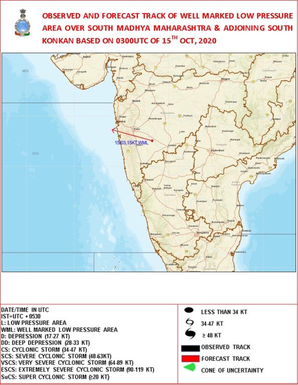
Well marked low pressure area persists over south Madhya Maharashtra & adjoining south Konkan
It is very likely to move west-northwestwards and emerge into eastcentral Arabian Sea off Maharashtra coast and concentrate into a Depression over eastcentral & adjoining northeast Arabian Sea off Maharashtra – south Gujarat coasts during next 48 hours. It is very likely to move gradually west-northwestwards and intensify further. Extremely heavy falls (more than 20cm per day) is likely over south Konkan and adjoining Ghat areas of Maharashtra. Sea condition will be rough to very rough; Fishermen are advised not to venture into the Sea
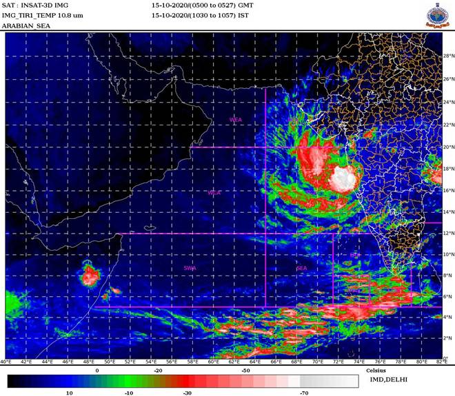
According to the Cyclone Warning Division of the India Meteorological Department (IMD):
The well marked low pressure area over south Madhya Maharashtra & adjoining south Konkan persisted over the same region at 0830 hrs IST of today, the 15th October 2020.
It is very likely to move west-northwestwards and emerge into eastcentral Arabian Sea off Maharashtra coast and concentrate into a Depression over eastcentral & adjoining northeast Arabian Sea off Maharashtra – south Gujarat coasts during next 48 hours. It is very likely to move gradually west-northwestwards and intensify further.
Warnings:
(i) Rainfall warning
- 15th October 2020: Light to moderate rainfall at most places with heavy to very heavy falls at isolated places would occur over Konkan & Goa and adjoining Ghat areas of Maharashtra. Extremely heavy falls (>20cm per day) is also likely over south Konkan and adjoining Ghat areas of Maharashtra.
- 16th October 2020: Light to moderate rainfall at most places with heavy to very heavy falls at isolated places would occur over Konkan & Goa and heavy falls at isolated places over coastal Districts of south Gujarat.
(ii) Wind warning
- Strong wind speed reaching 20-30 kmph gusting to 40 kmph very likely to prevail around the system centre and over Madhya Maharashtra during next 12 hours and gradually decrease thereafter. Strong wind speed reaching 25-35 kmph gusting to 45 kmph likely to prevail over east central and northeast Arabian Sea and along & off Maharashtra, Goa & south Gujarat coasts during next 12 hours.
- It would increase, becoming Squally wind speed reaching 40-50 kmph gusting to 60 kmph east central and northeast Arabian Sea and along & off Maharashtra, Goa & south Gujarat coasts from today evening.
- It would further increase becoming 50-60 kmph gusting to 70 kmph over eastcentral & adjoining northeast Arabian Sea and along & off Maharashtra & Gujarat coasts from 16th October evening and 55– 65 kmph gusting to 75 kmph over the same area from 17th October evening.
(iii) Sea condition
- Sea condition will be rough to very rough over eastcentral & adjoining northeast Arabian Sea and along & off Maharashtra & Gujarat coasts from today evening till 18th October.
(iv) Fishermen Warning
- Fishermen are advised not to venture into the Sea along & off Maharashtra & south Gujarat coasts and over eastcentral & adjoining northeast Arabian Sea from today, the 15th October onwards for the subsequent 3 days.
(v) Damage expected over Konkan & Goa and Ghat areas of Madhya Maharashtra
- Damage to paddy crops, banana, papaya trees and orchards & drumstick trees and Horticultural crops. Minor damage to Kutcha embankments due to heavy rain.
- Flooding / water logging in low lying areas, disruption of surface transport, landslides, water pooling etc. Also Roads could be wet & slippery.
- Clogging of Drainage system and flash floods due to heavy rains.
 For details kindly visit www.rsmcnewdelhi.imd.gov.in, www.imd.gov.in
Kindly download MAUSAM APP for location specific forecast & warning, MEGHDOOT
APP for Agromet advisory and DAMINI APP for Lightning Warning.