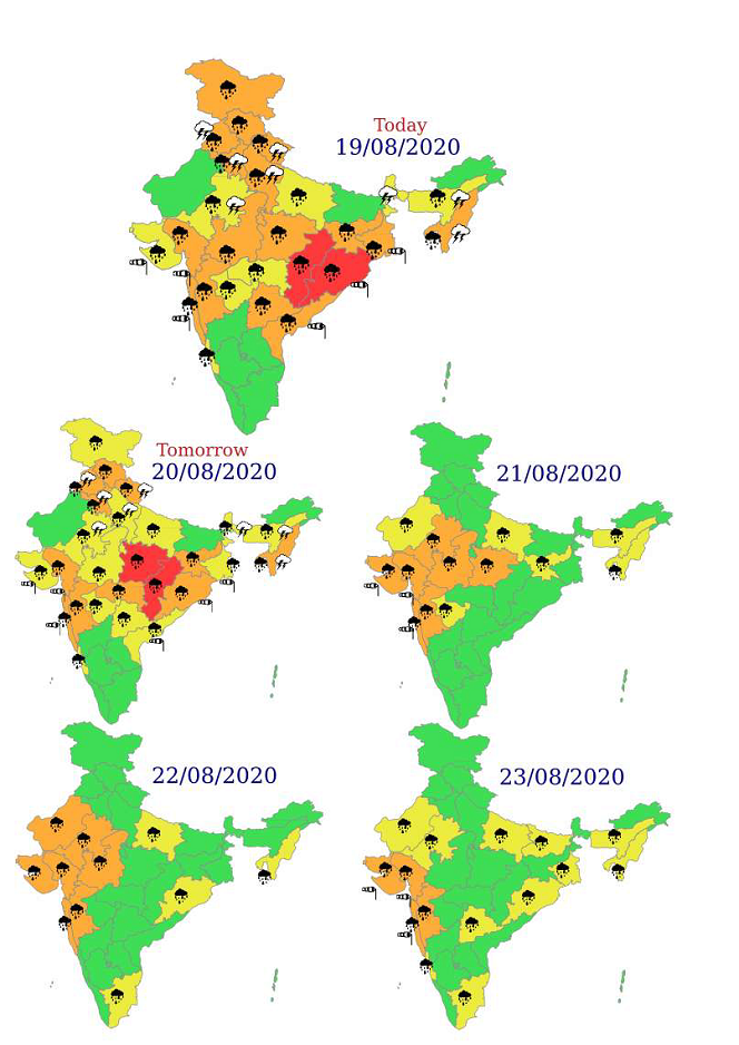
Intense rainfall spell over central parts of the country during next 5 days
Isolated extremely heavy falls over Odisha on 19th; Chhattisgarh on 19th & 20th; East Madhya Pradesh on 20th; West Madhya Pradesh on 21st & 22nd; East Rajasthan on 22nd and Gujarat State on 22nd & 23rd August, 2020. Isolated heavy to very heavy rainfall very likely over Jammu Division on 19th; Himachal Pradesh, Uttarakhand, Punjab, Haryana, Chandigarh & Delhi on 19th & 20th and West Uttar Pradesh on 19th August, 2020
According to the National Weather Forecasting Centre/Regional Meteorological Centre, New Delhi of the India Meteorological Department (IMD):
- A Well Marked Low Pressure Area lies over north coastal Odisha & neighbourhood. It is very likely to move westwards and concentrate into a Depression during next 24 hoursandaneast-westshearzonerunsroughlyalongLat.21°NacrosscentralIndiain mid troposphericlevels.
- Under the influence of above systems, widespread rainfall with isolated heavy to very heavy falls very likely along with isolated extremely heavy falls (≥ 20 cm) over Odisha on 19th; Chhattisgarh on 19th& 20th; East Madhya Pradesh on 20th; West Madhya Pradesh on 21st& 22nd; East Rajasthan on 22nd and Gujarat State on 22nd& 23rd August,2020.
- The monsoon trough is active and lies close to its normal position. It is very likely to be south of its normal position and active during next 4-5days.
- The convergence of strong moist southwesterly winds from the Arabian Sea over plains of Northwest India and Central India at lower levels very likely to continue during next 2days.
- Under the influence of above systems, fairly widespread to widespread rainfall activity with isolated heavy to very heavy rainfall very likely over Jammu Division on 19th; Himachal Pradesh, Uttarakhand, Punjab, Haryana, Chandigarh & Delhi on 19th & 20th and West Uttar Pradesh on 19th August,2020.
Impact expected over Odisha, Madhya Pradesh and Gujarat state
- Localized Flooding of roads, water logging in low lying areas and closure of underpasses mainly in urban areas of the aboveregion.
- Occasional reduction in visibility due to heavyrainfall.
- Disruption of traffic in major cities due to water logging in roads leading to increased traveltime.
- Minor damage to kutcharoads.
- Possibilities of damage to vulnerablestructure.
- LocalizedMudslides.
- Damage to horticulture and standing crops in some areas due toinundation.
- It may lead to riverine flooding in some river catchments (for riverine flooding please visit website of center water commission(http://www.cwc.gov.in/))
For specific district wise impact kindly visit IMD’s sate level meteorological center websites (https://mausam.imd.gov.in/imd_latest/contents/departmentalweb.php) and national website (https://mausam.imd.gov.in/).
Action Suggested
- Check for traffic congestion on your route before leaving for yourdestination.
- Follow any traffic advisories that are issued in thisregard.
- Avoid going to areas that face water logging problemoften.
- Avoid staying in vulnerablestructure.
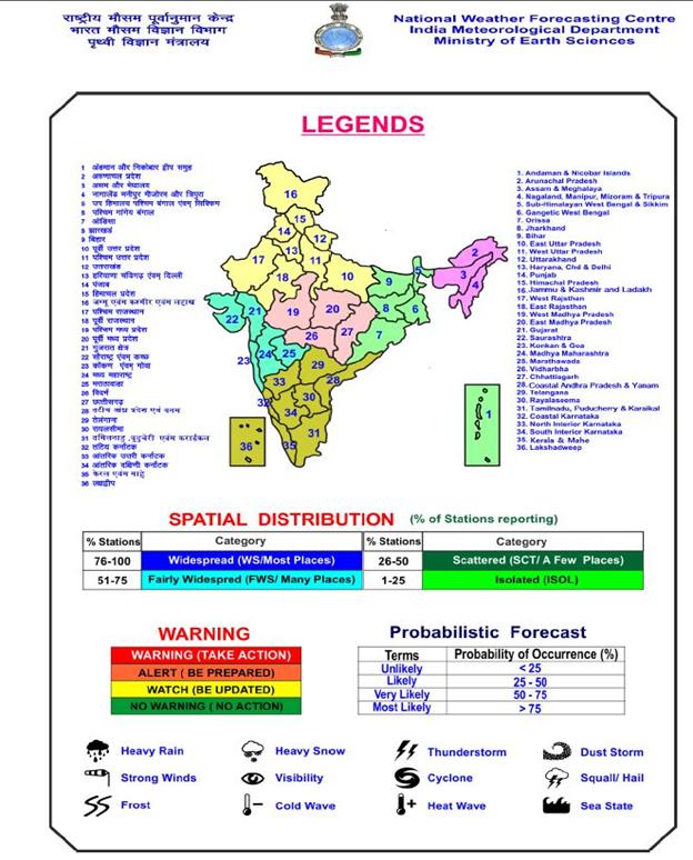 Legends: Heavy rain: 64.5-115.5 mm/day; Very heavy rain: 115.6-204.4 mm/day; Extremely heavy
rain: Greater or equal to 204.5 mm/day
For further details and forecast updates kindly visit websites of IMD, New Delhi:
http://www.mausam.imd.gov.in
For district level warning, kindly visit website of Meteorological Centres/Regional Meteorological Centres of IMDat state levels.
For lightning warning please visit Damini App.