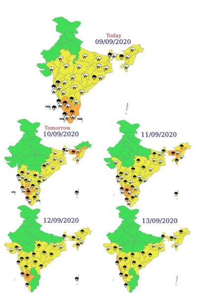
Extremely heavy rainfall at isolated places also very likely over Coastal & South Interior Karnataka on 11th September, 2020
The western part of the monsoon trough lies north of its normal position and the eastern end lies near to its normal position. A cyclonic circulation lies over Gangetic West Bengal and neighbourhood in lower tropospheric levels. Heavy rainfall at isolated places also very likely over Sub-Himalayan West Bengal & Sikkim during next 5 days; Odisha on 09th and over Northeast India during next 4-5 days. Rainfall distribution and intensity very likely to increase over Odisha, Coastal Andhra Pradesh & Yanam, Telangana, Vidarbha and adjoining areas from 12th September onwards
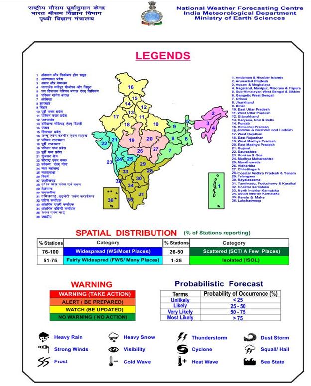
According to the National Weather Forecasting Centre/Regional Meteorological Centre, New Delhi of the India Meteorological Department (IMD):
Significant Weather Features (September 09, 2020):
♦ An off-shore trough at mean sea level runs from south Maharashtra coast to north Kerala coast. The east-west shear zone runs roughly along 13°N across the peninsular India at 3.1 km above mean sea level and a cyclonic circulation lies over Eastcentral Arabian Sea off Karnataka coast between 1.5 km and 5.8 km above mean sea level.
Under their influence:
-
- Fairly widespread to widespread rainfall with isolated heavy falls, thunderstorm & lightning very likely over Peninsular India during next 4-5 days.
- Heavy to very heavy rainfall at isolated places very likely over Coastal Karnataka during 10th-13th; South Interior Karnataka during 09th-12th; Kerala & Mahe during 09th-11th and Tamilnadu, Puducherry Karaikal on 09th September, 2020.
Extremely heavy rainfall at isolated places also very likely over Coastal & South Interior Karnataka on 11th September, 2020.
♦ The western part of the monsoon trough lies north of its normal position and the eastern end lies near to its normal position. A cyclonic circulation lies over Gangetic West Bengal and neighbourhood in lower tropospheric levels.
Under their influence:
-
- Fairly widespread rainfall with isolated thunderstorm & lightning very likely over Northeast and adjoining East India. Heavy rainfall at isolated places also very likely over Sub-Himalayan West Bengal & Sikkim during next 5 days; Odisha on 09th and over Northeast India during next 4-5 days.
♦ Under the influence of likely formation of a low pressure area over Westcentral Bay of Bengal off Andhra Pradesh coast around 13th September, rainfall distribution and intensity very likely to increase over Odisha, Coastal Andhra Pradesh & Yanam, Telangana, Vidarbha and adjoining areas from 12th September onwards.
♦ Moderate thunderstorm with lightning very likely at isolated places over East Uttar Pradesh, Bihar, Jharkhand, Odisha, Chhattisgarh, Vidarbha, Madhya Pradesh, Gujarat region, Rayalseema and Tamilnadu, Puducherry & Karaikal during next 12 hours.
FORECAST:
09 September (Day 1):
♦ Heavy to very heavy rainfall very likely at isolated places over South Interior Karnataka, Tamil Nadu, Puducherry & Karaikal and Kerala & Mahe; heavy rainfall at isolated places over Sub-Himalayan West Bengal & Sikkim, Odisha, Assam & Meghalaya, Madhya Maharashtra, Konkan & Goa, Rayalaseema, Coastal Karnataka and Lakshadweep.
- Thunderstorm accompanied with lightning very likely at isolated places over East Uttar Pradesh, East Rajasthan, Gujarat region, Madhya Pradesh, Vidarbha, Chhattisgarh, Bihar, Jharkhand, West Bengal & Sikkim, Odisha, Arunachal Pradesh, Assam & Meghalaya, Nagaland, Manipur, Mizoram & Tripura, Madhya Maharashtra, Marathwada, Konkan & Goa, Coastal Andhra Pradesh & Yanam, Telangana, Rayalaseema, Karnataka, Kerala & Mahe and Tamilnadu, Puducherry & Karaikal.
- Strong Wind (speed reaching 45-55 kmph) very likely over Southwest Arabian Sea; (speed reaching 40-50 kmph) over Gulf of Mannar and Comorin area. Squally Weather (wind speed reaching 40-50 kmph) over Southeast & Eastcentral Arabian Sea and along & off Kerala coast and Lakshadweep area; over Eastcentral & Southwest Bay of Bengal and along & off Tamil Nadu coast. Fishermen are advised not to venture into these areas.
10 September (Day 2):
♦ Heavy to very heavy rainfall very likely at isolated places over Assam & Meghalaya, Coastal & South Interior Karnataka and Kerala & Mahe; heavy rainfall at isolated places over Chhattisgarh, Sub-Himalayan West Bengal & Sikkim, Andaman & Nicobar Islands, Madhya Maharashtra, Konkan & Goa, Coastal Andhra Pradesh & Yanam, Telangana, Rayalaseema, North Interior Karnataka and Tamil Nadu, Puducherry & Karaikal.
- Thunderstorm accompanied with lightning very likely at isolated places over Chhattisgarh, Bihar, Jharkhand, West Bengal & Sikkim, Odisha, Assam & Meghalaya, Nagaland, Manipur, Mizoram & Tripura, Madhya Maharashtra, Marathwada, Konkan & Goa, Coastal Andhra Pradesh & Yanam, Telangana, Rayalaseema, Karnataka, Kerala & Mahe and Tamilnadu, Puducherry & Karaikal.
- Strong Wind (speed reaching 45-55 kmph) very likely over Southwest Arabian Sea; (speed reaching 40-50 kmph) over Gulf of Mannar and Comorin area. Squally Weather (wind speed reaching 40-50 kmph) over Southeast & Eastcentral Arabian Sea and Lakshadweep area; over Eastcentral & Southwest Bay of Bengal and along & off Tamil Nadu coast. Fishermen are advised not to venture into these areas.
11 September (Day 3):
♦ Heavy to very heavy rainfall at a few places with extremely heavy falls at isolated places very likely over Coastal Karnataka; heavy to very heavy rainfall at isolated places with extremely heavy falls at isolated places over South Interior Karnataka; heavy to very heavy rainfall at isolated places over Assam & Meghalaya and Kerala & Mahe; heavy rainfall at isolated places over East Madhya Pradesh, Vidarbha, Chhattisgarh, Bihar, Sub-Himalayan West Bengal & Sikkim, Andaman & Nicobar Islands, Arunachal Pradesh, Nagaland, Manipur, Mizoram & Tripura, Madhya Maharashtra, Konkan & Goa, Coastal Andhra Pradesh & Yanam, Telangana, Rayalaseema, North Interior Karnataka and Tamil Nadu, Puducherry & Karaikal.
- Thunderstorm accompanied with lightning very likely at isolated places over Bihar, Jharkhand, Gangetic West Bengal, Odisha, Assam & Meghalaya, Nagaland, Manipur, Mizoram & Tripura, Gujarat Region, Madhya Maharashtra, Marathwada, Konkan & Goa, Coastal Andhra Pradesh & Yanam, Telangana, Rayalaseema, Karnataka, Kerala & Mahe and Tamilnadu, Puducherry & Karaikal.
- Strong Wind (speed reaching 45-55 kmph) very likely over Southwest Arabian Sea; (speed reaching 40-50 kmph) over Gulf of Mannar and Comorin area. Fishermen are advised not to venture into these areas.
12 September (Day 4):
♦ Heavy to very heavy rainfall likely at isolated places over Coastal & South Interior Karnataka; heavy rainfall at isolated places over East Madhya Pradesh, Vidarbha, Chhattisgarh, Sub-Himalayan West Bengal & Sikkim, Odisha, Andaman & Nicobar Islands, Arunachal Pradesh, Assam & Meghalaya, Nagaland, Manipur, Mizoram & Tripura, Gujarat Region, Madhya Maharashtra, Marathwada, Konkan & Goa, Coastal Andhra Pradesh & Yanam, Telangana, North Interior Karnataka and Kerala & Mahe.
- Thunderstorm accompanied with lightning likely at isolated places over Jharkhand, Gangetic West Bengal, Assam & Meghalaya, Nagaland, Manipur, Mizoram & Tripura and Gujarat State.
- Strong Wind (speed reaching 45-55 kmph) likely over Southwest Arabian Sea and Westcentral Bay of Bengal . Fishermen are advised not to venture into these areas.
13 September (Day 5):
♦ Heavy to very heavy rainfall likely at isolated places over Konkan & Goa and Coastal Karnataka; heavy rainfall at isolated places over Vidarbha, Chhattisgarh, Sub-Himalayan West Bengal & Sikkim, Odisha, Arunachal Pradesh, Assam & Meghalaya, Gujarat Region, Madhya Maharashtra, Marathwada, Coastal Andhra Pradesh & Yanam, Telangana, Interior Karnataka and Kerala & Mahe.
- Thunderstorm accompanied with lightning likely at isolated places over Jharkhand, Gangetic West Bengal, Assam & Meghalaya, Nagaland, Manipur, Mizoram & Tripura and Gujarat State.
- Strong Wind (speed reaching 45-55 kmph) likely over Southwest Arabian Sea and Westcentral Bay of Bengal . Fishermen are advised not to venture into these areas.