

extremely heavy falls
- Ministry of Earth Science

A Low Pressure Area is likely to form over North Bay of Bengal & neighbourhood around 11th June
According to the National Weather Forecasting Centre of the India Meteorological Department (IMD): (Monday 07 June 2021, MID-DAY, Time of Issue:…
Read More » - India
‘Yaas’ very likely to cross North Odisha-West Bengal Coasts between Paradip and Sagar Islands close to North of Dhamra and South of Balasore, during noon of wednesday, with wind speed of 130-140 kmph gusting to 155 kmph
According to the National Weather Forecasting Centre of the India Meteorological Department (IMD): (TIME OF ISSUE: 0530 HOURS IST, DATED:…
Read More » - Ministry of Earth Science
‘Yaas’ very likely to move north-northwestwards, intensify further into a Very Severe Cyclonic Storm during next 12 hours
According to the National Weather Forecasting Centre of the India Meteorological Department (IMD): (TIME OF ISSUE: 1215 HOURS IST, DATED:…
Read More » - India
‘Yaas’very likely to move north-north-westwards, intensify further into a Very Severe Cyclonic Storm during next 12 hours; would continue to move north-north-westwards, intensify further and reach Northwest Bay of Bengal near north Odisha and West Bengal coasts very close to Chandbali-Dhamra port by the early morning of Wednesday, the 26th May
According to the National Weather Forecasting Centre of the India Meteorological Department (IMD): (TIME OF ISSUE: 0910 HOURS IST, DATED: 25.05.2021) The…
Read More » - India
‘Yaas’ very likely to move north-north-westwards, intensify further into a Severe Cyclonic Storm during next 12 hours and into a Very Severe Cyclonic Storm during subsequent 24 hours
According to the National Weather Forecasting Centre of the India Meteorological Department (IMD): Cyclonic Storm ‘Yaas’ (pronounced as ‘Yass’) over Eastcentral…
Read More » - Ministry of Earth Science
Depression very likely to move north-north-westwards and intensify into a Cyclonic Storm by 24th May morning and further into a Very Severe Cyclonic Storm during the subsequent 24 hours
According to the National Weather Forecasting Centre of the India Meteorological Department (IMD): (Time of issue: 1500 hours IST, Dated: 23-05-2021, INDIA METEOROLOGICAL DEPARTMENT)…
Read More » - India
Thunderstorm, lightning & squall very likely at isolated places over Andaman Nicobar Islands; lightning & gusty winds very likely at isolated places over East Rajasthan on 22nd May
According to the National Weather Forecasting Centre of the India Meteorological Department (IMD): All India Impact Based Weather Warning Bulletin (Saturday 22 May 2021 Time of Issue: 1400 hours IST) 22 May (Day 1): ♦ Thunderstorm with lightning & squall (speed reaching 50-60 kmph gusting 70 kmph) very likely at isolated places over Andaman & Nicobar Islands; with lightning…
Read More » - Ministry of Earth Science
Cyclone “Tauktae”very likely to move north-eastwards and weaken gradually into a Well-Marked Low pressure area during next 12 hours; remnant of the system is very likely to move further north-eastwards across Rajasthan to west Uttar Pradesh during the next two days
According to the National Weather Forecasting Centre of the India Meteorological Department (IMD): (TIME OF ISSUE: 0745HOURS IST, DATED: 19.05.2021, INDIA…
Read More » - India
Cyclonic Storm “Tauktae” very likely reach Gujarat coast in the evening hours of 17th& cross Gujarat coast between Porbandar & Mahuva (Bhavnagar district) during early hours of 18th May as a Very Severe Cyclonic Storm with a maximum sustained surface wind speed 155-165 kmph gusting to 185 kmph
According to the National Weather Forecasting Centre of the India Meteorological Department (IMD): (TIME OF ISSUE:0415HOURS IST, DATED: 17.05.2021, INDIA…
Read More » - India
Very Severe Cyclonic Storm “Tauktae” (over Eastcentral Arabian Seainto an Extremely Severe Cyclonic Storm:Cyclone Warning & post landfall outlook for Gujarat & Diu coasts (Red message)
According to the National Weather Forecasting Centre of the India Meteorological Department (IMD): (TIME OF ISSUE:815HOURS IST, DATED: 17.05.2021, INDIA…
Read More » - India
Cyclone “Tauktae” very likely to move north-north-westwards and reach Gujarat coast in the evening hours of 17th& cross Gujarat coast between Porbandar & Mahuva (Bhavnagar district) during the night (2000 – 2300 hrs IST) of 17th May with a maximum sustained wind speed 155-165 kmph gusting to 185 kmph
According to the National Weather Forecasting Centre of the India Meteorological Department (IMD): (TIME OF ISSUE: 1100 HOURS IST, DATED: 17.05.2021, INDIA…
Read More » - India
Cyclone “Tauktae” very likely to move north-north-westwards and reach Gujarat coast in the evening hours of 17th& cross Gujarat coast between Porbandar & Mahuva (Bhavnagar district) during the night (2000 – 2300 hrs IST) of 17th May with a maximum sustained wind speed 155-165 kmph gusting to 185 kmph
According to the National Weather Forecasting Centre of the India Meteorological Department (IMD): (TIME OF ISSUE: 1300HOURS IST, DATED: 17.05.2021, INDIA…
Read More » - India
Cyclonic Storm “Tauktae” very likely to intensify during next 24 hours; very likely to move north-north-westwards and reach Gujarat coast in the evening hours of 17th& cross Gujarat coast between Porbandar & Mahuva (Bhavnagar district) around 18th May early morning
According to the National Weather Forecasting Centre of the India Meteorological Department (IMD): (TIME OF ISSUE: 0810 HOURS IST, DATED:…
Read More » - India
Thunderstorm with lightning, hail & squall (speed reaching 50-60 kmph) very likely at isolated places over Punjab, Haryana, Chandigarh & Delhi today
Heavy rainfall very likely at isolated places over Uttarakhand, West Bengal, Sikkim, Odisha, Arunachal Pradesh, Assam, Meghalaya, Nagaland, Manipur, Mizoram,…
Read More » - India
Deep Depression over southwest and adjoining southeast Bay of Bengal (Cyclone Alert for South Tamilnadu and South Kerala coasts – Yellow Message)
According to the Cyclone Warning Division of the India Meteorological Department (IMD): Yesterday’s depression over southeast Bay of Bengal moved…
Read More » - India
Depression formed over southeast Bay of Bengal & neighbourhood
According to the Cyclone Warning Division of the India Meteorological Department (IMD): Latest satellite and Ship observations indicate that the…
Read More » - India
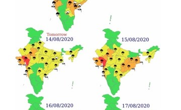
Heavy to very rainfall with extremely heavy falls very likely at isolated places over Gujarat region
Forecast based upon 0830 IST / 0300 UTC OF 13-08-2020 Forecast Generally cloudy sky. Moderate Rain/Thundershowers. Impact…
Read More » - India
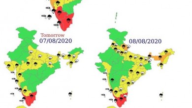
Widespread rainfall with isolated/ scattered heavy to very heavy falls most likely to continue over Gujarat state, Konkan & Goa and Madhya Maharashtra (ghat areas) during next 24 hours and decrease thereafter
Significant Weather Features dated 06.08.2020 ♦ Monsoon trough is active and is south of its normal position. Its western end…
Read More »